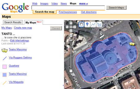
Ecco l’ennesimo prodotto di costruzione di mappe online: Google My Maps. Ve lo trovate andando su Google Maps, sulla sinistra. Cliccate sul tab “My Maps” e cliccate su “Create new map”.
Vi troverete davanti un editor cartografico online, che vi darà la possibilità di aggiungere punti, linee e poligoni, di formattarli (con una buona scelta di opzioni) e di arrichirli con informazioni ipertestuali (testi, foto, video, etc.). Per l’integrazione di queste informazioni è stato messo a disposizione un editor di testo utilizzabile sia in modalità WYSIWYG, che in semplice modalità testuale.
Le mappe create si possono ovviamente salvare e condividere con altri. E’ altresì possibile esportarne il contenuto in formato .kml (Google Earth).
E’ un peccato che non ci sia la possibilità di inserire le mappe create, all’interno del proprio sito e/o blog; a questo proposito Tagzania è uno strumento più raffinato che vi da anche la possibilità di esportare la mappa creata in formato GEORSS.

Ecco alcuni esempi (via official Google Blog):
- America’s Highway: Oral Histories of Route 66: A glimpse into life on the legendary (and now-decommissioned) highway, and what drivers will find there today
- Around Japan in 28 Days: Catalogs a trip across Japan that can be done in 3 weeks
- 2004 Presidential Election: Red states, blue states, and election stats for each
- The World of Hello World: A map of programming languages and rough locations in the world where they were created
- Olympic Host Cities: Cities that have hosted the Olympic Games with links to related Wikipedia information
- The Googleplex: A photo essay on life at the Google headquarters in Mountain View
- Monster Sightings: Locations of monster sightings across the globe
Buon divertimento!
I contenuti potrebbero non essere più adeguati ai tempi!


