11 novembre, 2013 | di Giancarlo Antonello
Ho molto pensato se scrivere o no queste poche righe, perché potrebbe sembrare che lo facessi per “sponsorizzare” un progetto che a me piace; alla fine ho deciso che in ogni occasione ci sono i maligni e quelli in buona fede e così vi invio queste mie considerazioni, pensando che apparteniate alla seconda categoria.
Sono più di tre anni che uso geopaparazzi, cioè fin dalla sua nascita con i suoi bachi e i suoi problemi. Mi sento onorato di aver contribuito allo sviluppo di questo software, sia pure in modo passivo, nel senso che non ho scritto neppure una linea di programma ma ho testato il software in lungo e in largo per i miei bisogni di turista fai da te.
Due anni fa, durante una vacanza in un’isola greca con mia moglie, seguendo con la cartina del luogo un sentiero segnato male ci siamo persi.
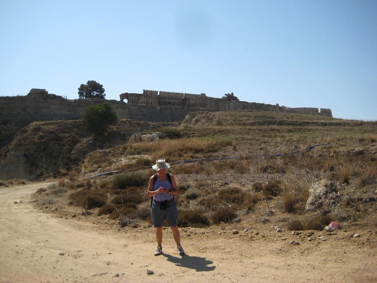
Fortezza di Antimachia a Karadameno, Isola di Kos. Geopaparazzi su HTC Wildfire.
Erano le tre del pomeriggio e c’era il sole, ma … fortunatamente avevo scattato molte foto e aiutandomi un po’ con le immagini e un po’ con il ricordo dell’orografia del luogo riuscimmo, per altra via e con tre ore aggiuntive, a ritornare al luogo di partenza. Mi dissi: mai più dovrà ripetersi un caso analogo!
E da quel giorno geopaparazzi mi segue ovunque.
Vi scrivo alcuni accadimenti banali, ma credo significativi, per far capire ai vostri lettori eventualmente interessati come sia utile questo strumento.
- Mia moglie ed io per i nostri viaggi ci affidiamo regolarmente al sito booking.com. Di solito sono abbastanza precisi, ma… vi lascio intendere dalla email che mia moglie ha mandato al sito durante le vacanze:
“Gentili Signori, siamo utenti di booking.com e abbastanza soddisfatti del servizio che viene riservato. Tuttavia abbiamo un’osservazione da fare: essendo dotati di GPS per rintracciare agevolmente la struttura dove andremo a pernottare, abbiamo rilevato che le strutture alberghiere a Kalymnos -vedi hotel Panorama- ed a Astypalaia -vedi studio Ixthioessa- ma anche altre di cui abbiamo verificato la posizione (vista mare studios: sulla vostra mappa è segnalato in collina ed invece è a un centinaio di metri dal porto), sono segnalate nelle vostre mappe a distanze variabili da 500 a 1000 metri rispetto alla posizione reale. E’ importante che le coordinate GPS corrispondano alla posizione reale della struttura perchè è anche in base alla posizione della stessa che si fa la scelta.
Ixthioessa ad Astypalaia: sulla Vs. mappa: lat 36.54874 lon 26.35278 a noi risulta lat: 36.54978 lon: 26.35557
Vi chiediamo di verificare e rettificare le posizioni.
Cordiali saluti luciana a.”
-
Quest’estate ero a cercar funghi con un gruppo di amici; all’ora di tornare alla base l’opinione sulla via del ritorno da prendere non era esattamente condivisa: alcuni dicevano “di qua” altri “di là”. Prendemmo una delle due direzioni e, fatti pochi metri, il mio amico geopaparazzi mi mostrò che la direzione era sbagliata. Ovviamente la rettifica fu immediata e alcuni amici si mostrarono interessati a quello strumento.
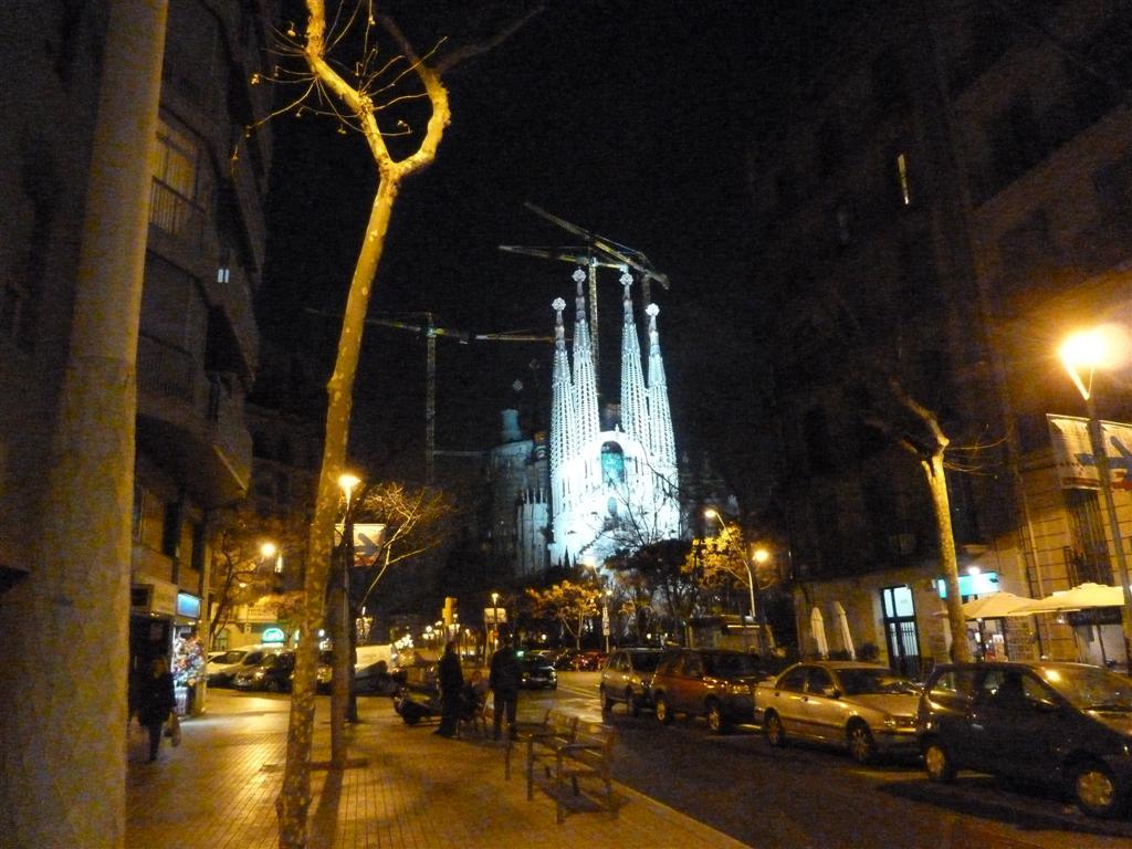
Al ritorno verso l’albergo, guidati da geopaparazzi, nella Barcellona notturna.
- Ero in ferie con mia moglie a Barcellona (ebbene sì, sono spesso in giro perchè sono in pensione da dodici anni ormai) per la prima volta, e visitando la città è difficile rendersi conto di quanto passi velocemente il tempo se non quando si accendono le illuminazioni stradali e improvvisamente ci si sente sperduti. Naturalmente in una città non c’è rischio di perdersi (taxi e indirizzo dell’albergo risolvono tutti i casi) ma l’idea di vedere anche aspetti della città notturna ci piaceva e così ci permettemmo una serata tarda in luoghi qualsiasi con la certezza che geopaparazzi ci avrebbe riportati a casa. In albergo mia moglie mi disse “regala 50€ per una pizza a chi ha sviluppato quel marchingegno (proprio così disse: marchingegno!)” e così feci: non succede spesso che una donna apprezzi così apertamente certa tecnologia ….
-
Un amico camminatore con poca esperienza delle montagne del meranese mi chiese un giorno di indicargli un bel percorso in alta quota. Stavo per raccontargli una delle mie gite, quando mi venne l’illuminazione. “che cellulare hai?” gli chiesi. Mi fece vedere un HTC. “Magnifico” dissi. E gli spiegai come scaricare Geopaparazzi, come vedere i percorsi in Google Earth, ecc. ecc.. “Ti manderò via e-mail le istruzioni per usare quel software insieme al file del percorso che stavo per raccontarti. Se avrai problemi, telefonami”. Ci lasciammo così e gli inviai quanto promesso. Era un mercoledì (lo ricordo perchè la storia è recente) e il lunedì successivo mi arrivò una sua e-mail carica d’entusiasmo sia per il luogo visto che, soprattutto, per la semplicità con cui aveva potuto seguire il percorso.
Potrei raccontare ancora per molto, ma credo di aver superato il limite di tolleranza di ogni buon lettore “scientifico”.
Nel frattempo il mio hardware si è evoluto. L’HTC era troppo lento e spesso “crashava” per la mia impazienza a spostare le mappe sul monitor. In giugno 2013 mi sono regalato un Samsung Galaxy Note2 N7100: una bomba!!! Ci ha accompagnati ad Astypalea (Grecia) senza un attimo di incertezza. Sarà la ns. guida fino a quando… non sarà diventato troppo lento anche lui.
Ci sono ancora alcune cose che mi piacerebbe veder fare a geopaparazzi ma mi rendo conto che non posso sempre chiedere e mai dare. Sono sicuro, tuttavia, che l’autore di geopaparazzi continuerà, come nel passato, a curare lo sviluppo e la manutenzione di questo software che ormai chiamo “geofriend” e prima o poi i miei desideri saranno esauditi perchè saranno diventati necessità per molti.
Per finire un consiglio ai turisti fai da te: è sempre bene viaggiare anche con una cartina della zona, oltre che con geopaparazzi: qualche volta batterie e/o satelliti giocano brutti scherzi…
Grazie per l’ospitalità sul Vostro guest post e per la vostra attività su TANTO.
Posted in GuestPost, Strumenti | 5 Comments »
7 novembre, 2011 | di Andrea Antonello
 Unce upon a time there was a hot summer and dark room. And there was a lazy nerdy Sunday morning. I remember quite well that weekend.
The time was up to try to develop something on Android. In the past I had tried to develop applications on Zaurus, on Dell Axim, on some Nokia smartphone, but the results had been disappointing every time. There had to be something easier, where one could throw his ideas and make simple applications out of it… in one weekend.
The nerdy Sunday, wakeup call at 6, checking emails with coffe’ and cookies, seemed to be inspiring. A couple of days before an email had arrived about a new book, available in “review-reading” mode as pdf version: Unlocking Android, a developer’s guide by Ableson et alter. I decided to give it a possibility.
Well, I found the book so easy to read through, that I gave the first application a try. I really wanted to create a lightweight application that would help out in field surveys and would have those features, that the tablet pc field mapping application didn’t have. Above all the possibility to record the orientation of the pictures taken during the survey, so that they would show the direction of the snapshot when imported on a map. And I really liked the idea of having a mapping device always in my pocket. The motto has always been: “Gather as much information as you can. Always. The GIS will then help you to sort it out.”
That Sunday experiment went way better than I had ever hoped, by the evening I had great satisfaction with my simple, new and most of all GPS logging application. It was already able to take text notes and track lines. I got really excited about the possibilities to create a small version of BeeGIS… well, at that point I knew the time was up for Geopaparazzi.
From that moment on things went quite smooth. We started developing a simple OpenStreetMap based view, we created an import tool for Geopaparazzi in BeeGIS. We were using it in our daily job, and that was simply awesome. As we usually do at HydroloGIS we open sourced the application and published it on the market, in the hope that people would buy it and through that act support our other open source projects: JGrasstools, JGrass, BeeGIS and uDig.

The first Geopaparazzi
The thing we were most proud of, was that it would handle shooting direction:

The compass tracks the picture shooting direction, when the user keeps the phone in "taking picture" mode.
which, once imported into BeeGIS, would result in geonotes containing the picture and showing through a small arrow the direction in which the photo had been taken:

Geopaparazzi survey data imported into BeeGIS. The small arrows show the direction of the snapshot, the note itself contains the image.
As time passes by and as open source software works, one starts to exploit components other teams are specialized in.
So at some point Geopaparazzi decided to remove the compass view to present the much more user friendly dashboard. The android system makes it very easy to call views from other applications. geopaparazzi therefore chose to present a compass button that calls the compass view from the Status GPS project, which is freely available in the market.

The Status GPS compass view
At that point Geopaparazzi 2 was released, which brought a new, more userfriendly dashboard view:

The main view of Geopaparazzi 2
From the beginning Geopaparazzi only wanted to deal with data collection, which is why with the time the possibilities to describe the data to collect were enhanced. The new form based tags were introduces, through which it is possible to describe the data structure as forms that appear as tag buttons:

The form file description is loaded as a set of buttons that call the actual form
Once the button is pushed, the form is generated from a user created description:

A form, generated on the fly from a user defined text
Geopaparazzi 2 also brought the integration with the osmdroid project, a project that supplies a map view that caches OSM map tiles that can be accessed also in offline mode. This gave the possibility to enhance a bit the usability of the map view, also adding the bookmarks facility:

The osmdroid based map view, with Geopaparazzi's measure tool, bookmarks and notes tools
That more or less brings us to where we are now. Some interest has grown around Geopaparazzi and that makes us very happy.
The Osaka Water General Service together with the Osaka University has adapted it to use it for the collection of information about water-supply infrastructure to promote post-disaster recovery for water supply under the guidance of Venkatesh Raghavan.

The Japanese localized Geopaparazzi adaption used in the Disaster Management Information System of the city of Osaka
We worked on a customized version of Geopaparazzi to keep waste management information uptodate. Through the trashmapper it is possible to sample and update information out in the field and then syncronize the data with a central database/webgis.
Since in this project the new generation tablets are being used, we got to tweak it for better user experience on tablet screens:

The TrashMapper application that helps collecting data about waste management
Arrived to that point, it was about time to move to the next level. Geopaparazzi has always been a free and open source application. It was sold in the android market but the code has always been accessible. What we want to achieve now that it is a stable product, is to attract some developers to cooperate on the project and enhance its functionalities. That is why from today on Geopaparazzi can be found in the market for free. From today on it is not only free as in speech, but also as in beer.
A few final considerations: the new generation tablets are more or less like pcs and maybe the idea to avoid too much mapping capabilities in Geopaparazzi might be a decision that it is time to review. Maybe instead it is time Geopaparazzi starts to slowly take over the job of old and heavy BeeGIS, with new data and connectivity functionalties and mapping capabilities. The doors are open, even if the main paradigma has to be kept strickt in mind: the tools needs to stay as simple and usable as possible. If you are interested to contribute, feel free to stop by at our mailinglist and have a chat with us. If you want to try it out, simply access the market and search for geopaparazzi.
Posted in osgeo, Strumenti | No Comments »