![]() Unce upon a time there was a hot summer and dark room. And there was a lazy nerdy Sunday morning. I remember quite well that weekend.
Unce upon a time there was a hot summer and dark room. And there was a lazy nerdy Sunday morning. I remember quite well that weekend.
The time was up to try to develop something on Android. In the past I had tried to develop applications on Zaurus, on Dell Axim, on some Nokia smartphone, but the results had been disappointing every time. There had to be something easier, where one could throw his ideas and make simple applications out of it… in one weekend.
The nerdy Sunday, wakeup call at 6, checking emails with coffe’ and cookies, seemed to be inspiring. A couple of days before an email had arrived about a new book, available in “review-reading” mode as pdf version: Unlocking Android, a developer’s guide by Ableson et alter. I decided to give it a possibility.
Well, I found the book so easy to read through, that I gave the first application a try. I really wanted to create a lightweight application that would help out in field surveys and would have those features, that the tablet pc field mapping application didn’t have. Above all the possibility to record the orientation of the pictures taken during the survey, so that they would show the direction of the snapshot when imported on a map. And I really liked the idea of having a mapping device always in my pocket. The motto has always been: “Gather as much information as you can. Always. The GIS will then help you to sort it out.”
That Sunday experiment went way better than I had ever hoped, by the evening I had great satisfaction with my simple, new and most of all GPS logging application. It was already able to take text notes and track lines. I got really excited about the possibilities to create a small version of BeeGIS… well, at that point I knew the time was up for Geopaparazzi.
From that moment on things went quite smooth. We started developing a simple OpenStreetMap based view, we created an import tool for Geopaparazzi in BeeGIS. We were using it in our daily job, and that was simply awesome. As we usually do at HydroloGIS we open sourced the application and published it on the market, in the hope that people would buy it and through that act support our other open source projects: JGrasstools, JGrass, BeeGIS and uDig.
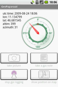
The thing we were most proud of, was that it would handle shooting direction:
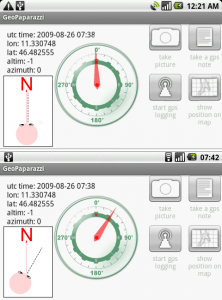
The compass tracks the picture shooting direction, when the user keeps the phone in "taking picture" mode.
which, once imported into BeeGIS, would result in geonotes containing the picture and showing through a small arrow the direction in which the photo had been taken:
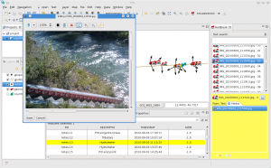
Geopaparazzi survey data imported into BeeGIS. The small arrows show the direction of the snapshot, the note itself contains the image.
As time passes by and as open source software works, one starts to exploit components other teams are specialized in.
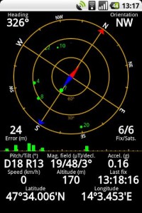
So at some point Geopaparazzi decided to remove the compass view to present the much more user friendly dashboard. The android system makes it very easy to call views from other applications. geopaparazzi therefore chose to present a compass button that calls the compass view from the Status GPS project, which is freely available in the market.
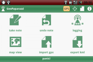
At that point Geopaparazzi 2 was released, which brought a new, more userfriendly dashboard view:
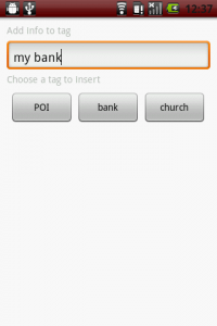
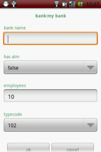
From the beginning Geopaparazzi only wanted to deal with data collection, which is why with the time the possibilities to describe the data to collect were enhanced. The new form based tags were introduces, through which it is possible to describe the data structure as forms that appear as tag buttons:
Once the button is pushed, the form is generated from a user created description:
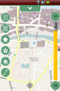
Geopaparazzi 2 also brought the integration with the osmdroid project, a project that supplies a map view that caches OSM map tiles that can be accessed also in offline mode. This gave the possibility to enhance a bit the usability of the map view, also adding the bookmarks facility:
That more or less brings us to where we are now. Some interest has grown around Geopaparazzi and that makes us very happy.
The Osaka Water General Service together with the Osaka University has adapted it to use it for the collection of information about water-supply infrastructure to promote post-disaster recovery for water supply under the guidance of Venkatesh Raghavan.
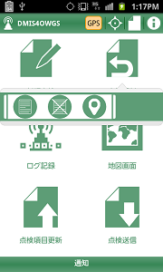
The Japanese localized Geopaparazzi adaption used in the Disaster Management Information System of the city of Osaka
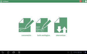
We worked on a customized version of Geopaparazzi to keep waste management information uptodate. Through the trashmapper it is possible to sample and update information out in the field and then syncronize the data with a central database/webgis.
Since in this project the new generation tablets are being used, we got to tweak it for better user experience on tablet screens:
Arrived to that point, it was about time to move to the next level. Geopaparazzi has always been a free and open source application. It was sold in the android market but the code has always been accessible. What we want to achieve now that it is a stable product, is to attract some developers to cooperate on the project and enhance its functionalities. That is why from today on Geopaparazzi can be found in the market for free. From today on it is not only free as in speech, but also as in beer.
A few final considerations: the new generation tablets are more or less like pcs and maybe the idea to avoid too much mapping capabilities in Geopaparazzi might be a decision that it is time to review. Maybe instead it is time Geopaparazzi starts to slowly take over the job of old and heavy BeeGIS, with new data and connectivity functionalties and mapping capabilities. The doors are open, even if the main paradigma has to be kept strickt in mind: the tools needs to stay as simple and usable as possible. If you are interested to contribute, feel free to stop by at our mailinglist and have a chat with us. If you want to try it out, simply access the market and search for geopaparazzi.
Tag: android geopaparazzi mobile
I contenuti potrebbero non essere più adeguati ai tempi!


