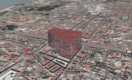
E’ uscita una nuova release di Google Earth 4 (beta) con delle novità interessanti anche nella versione free. Tra queste la più appariscente, e tra le più desiderate, c’è quella di tracciare percorsi e poligoni. Questi si possono formattare graficamente e si possono anche estrudere (come nella figura sottostante).

A seguire le altre novità:
- Greatly improved printing of driving directions and folders
- New placemark icon that better indicates location. Expanded icon palette
- Separation of placemarks in the same location when clicked
- Ground overlays can be drawn at altitude (e.g. floor plans for multiple stories)
- Places icon for polygons and lines now matches geometry
- Pro premium features now included in Pro at no extra charge
- Increased limits for manually entered navigation options (e.g. speed)
- DXTC texture compression for models and ground overlays (adjustable in Tools->Options)
- Incremental loading of jpg textures in collada files
- Site wide install (using silent install)
- SketchUp models more closely match brightness of same models as they appear in SketchUp
- Japanese GUI font changed to “MS UI Gothic” for legibility
- Support for Magellan Explorist GPS devices
Tag: google-earth
I contenuti potrebbero non essere più adeguati ai tempi!


